Addressing the Issue: How to Deliver on Physical Addresses for the Poor
Feb 3, 2016
Did you know that 4 billion people the world over make do every day without a physical address? Consider the last time you opened a bank account or applied for a loan—you were probably asked for a home address to verify your identity. Imagine calling an ambulance in an emergency situation and trying to explain where you were if your street had no name and your home had no number. How would you register to vote? How would you get supplies to and from your office?
Where the Streets Have No Name
For the individual, not having a physical address can be tantamount to not having a registered identity, making seemingly basic and often essential tasks difficult. Participating in political processes, accessing finance, and conducting business that involves delivery of official documents can all be excruciatingly time-consuming endeavors in areas where people live off the radar. The same is true for enterprises whose efficiency and reach is limited by reliance upon ad-hoc local networks to physically link goods and services.
Large sums of money have been invested in developing addressing systems in areas around the world lacking them. These traditional approaches such as the several attempts in Ghana to map and name city streets require significant time and funding, relying heavily upon local governments with limited capacity. As a result, those without addresses continue to rely upon informal, patchy solutions to the delivery of goods and services, and small businesses bear the burden of creating their own logistics infrastructure instead of relying on third-party services. Inferior addressing systems don’t only affect poor populations and vulnerable small businesses: Even in well-addressed countries, new, more flexible ways of sharing location information are being explored, such as the Natural Area Coding System developed by NAC Geographic Products Inc. The greatest potential for social impact, however, is in those places without an address infrastructure already in place.
Enter GPS Technology
The proliferation of mobile technology has already made it easier to connect with informal communities largely under the radar. Connecting these communities with public and private services empowers them to improve livelihoods, and GPS-based innovations may have the potential to offer them a work-around for areas lacking public infrastructure. Some startups have taken up the issue of physical addressing with GPS specifically for this purpose:
OkHi: Changing the Game
In 2014, OkHi was voted the best startup in the booming Kenyan startup scene at the Seedstars world competition. The Nairobi-based startup has received funding from notable Silicon Valley investors to deliver on its mission to empower Kenyan residents with a working address simply and effectively. The app uses geo-tagged photographs of the user’s front door/gate to allow the user to share his or her location via WhatsApp, SMS, or email.
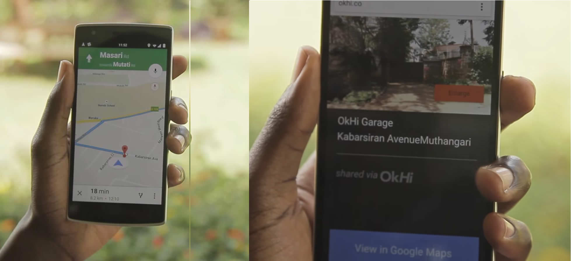
An OkHi address consists of a location on Google Maps and a photo of the front of the address to allow the user to know that he or she is at the right door.
OkHi’s founder and CEO Timbo Drayson says the startup has initially worked with e-commerce companies and has helped them cut delivery times by 50 percent. Drayson sees the technology as offering a simple and effective way to physically connect people without addresses to improve the delivery of public and private services, as well as to provide people with another form of identity proof, helping them qualify for services.
The startup has gained local visibility, but its ambition is much broader. Drayson hopes that this simple approach will eventually be adopted globally by users around the world looking to connect with each other.
What3Words
While OkHi enables users to share their individual locations with targeted users, UK-based What3Words is working on allowing people to locate each other without actively having to tag their location. Instead, What3Words’ approach automatically assigns every location an address, essentially taking over the mapping and addressing responsibility usually handled by local municipalities. How is this done? It’s simple.
The company has sliced the world into 3x3-meter square grids, and assigned each grid square a unique combination of three words to avoid using GPS coordinates to describe a location. A user can find the unique three-word combination associated with his or her specific location.
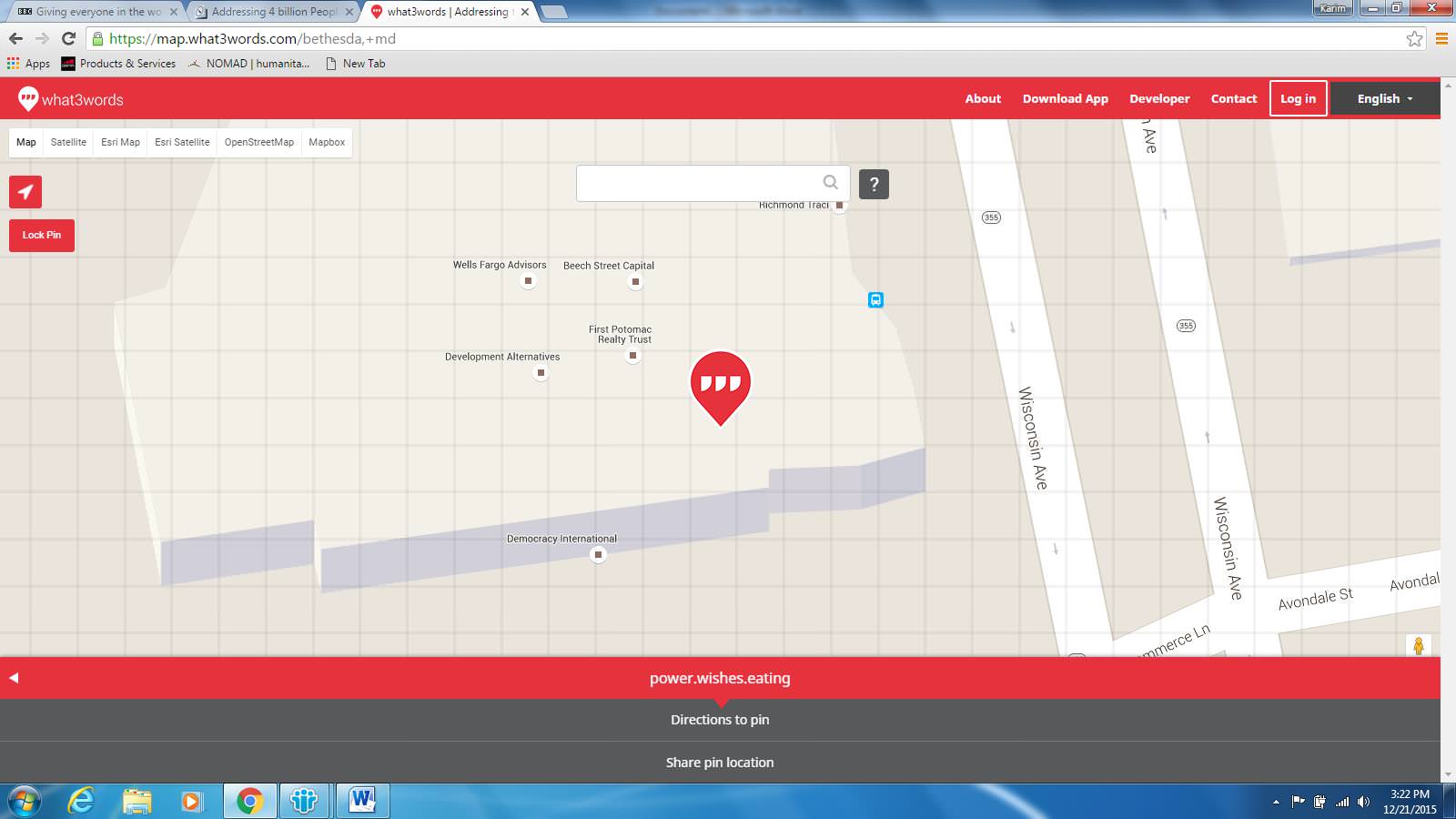
The location of my desk at DAI’s Bethesda offices is represented by the words "power.wishes.eating"
In Rio de Janeiro, a local company Grupo Cartero Amigo set up a postal system in the country’s largest favela not served by the Brazilian national postal system. The case is a model for how such a system might be used by actors the world over.
Whether it is used for applications that require active user geo-tagging or for those that don’t, mobile GPS technology clearly represents a possible game changer for individuals, businesses, and even public institutions operating in the world’s vast unaddressed areas. How quickly and successfully such usage scales remains to be seen.